The Science
The Science Behind Moon Phase Prints
This page explains how our Moon Phase Prints are calculated precisely, and why accuracy requires more than just data. Accurately representing the Moon at a specific moment is complex due to the following things listed in this report. Your Moon Map / Moon Phase Print is a bespoke work of art and science.
Optimally Visible Moon Maps – with the Culmination Moon Map Method™
1.0 Visible Moon Maps Only
We established custom Moon Phase Prints in 2018 and developed the Culmination Moon Map Method™ to address a common problem with moon maps: visibility. other providers offered moon maps which where not visible at all, and in fact the moon was physically on the wrong side of the world. Observing the moon would require looking through the Earth. We do not consider this an accurate representation. For that reason, we developed the Culmination Moon Map Method™, which ensures that the Moon shown in each print was physically visible in the sky from the selected location.
There are some rare geographical cases where a visible Moon cannot be calculated simply because it is not visible for extended periods due to physical astronomical constraints. This occurs in extreme polar regions, (north pole and south pole) where the geometry of the Earth–Moon–Sun system prevents the Moon from rising above the horizon for long durations. However, after rendering over 20,000 Moon Phase Prints, every moon map has been generated using the Culmination Moon Map Method™ without the need to revert to approximate calculations. This is predictable based on population coverage: Our visibility led Culmination Moon Map Method™ applies to 99.95% of the world’s population.
2.0 Culmination Moon Map Method™
We developed the Culmination Moon Map Method™ to ensure Moon Phase Prints are rendered at a moment when the Moon was physically visible from the selected location.
For a given date and location, the Moon is continuously moving across the sky. Its altitude, orientation, and illumination change minute by minute as the Earth rotates and the Moon progresses along its orbit. We calculate the precise moment when the Moon reaches its highest point above the horizon for the selected location. This moment is known as lunar culmination.
Culmination is calculated with time precision down to the millisecond to ensure the Moon Map is rendered at its optimal viewing position. At this moment, the Moon is fully above the horizon, atmospheric effects are minimised for that night, and the geometric relationship between the Sun, Earth, and Moon is most stable for accurate rendering. Rendering the Moon at culmination improves accuracy not only in terms of visibility, but also in surface shading, illumination angle, and overall image fidelity when compared to calculations made earlier or later in the same day.
Why timing matters - Even a difference of 30–60 minutes can measurably change lunar altitude, illumination angle, and surface shading. Culmination ensures the Moon is rendered at the optimal moment for that date and location, calculated with millisecond-level precision.
3.0 What determines Moon Map Accuracy
Accurately rendering the Moon for a specific date, time, and geographic location is a precise astronomical process. The Moon’s visible appearance is not defined by phase alone, but by multiple interacting variables that must be calculated together to produce an accurate representation.
These variables include:
- the geometric relationship between the Sun, Earth, and Moon
- the Moon's orbital position, velocity, and distance
- lunar illumination and the position of the terminator
- lunar libration and surface orientation
- the observer's geographic location on Earth (topocentric perspective)
- the Moon's altitude above the horizon at the time of observation
- atmospheric path length and refraction effects near the horizon
- precise timekeeping and time zone conversion for the selected location
These factors do not operate independently. Small inaccuracies in timing, position, or reference frame can compound across calculations, resulting in a Moon representation that differs measurably from what was physically observable from the selected location.
4.0 Sun Path
The Sun’s path plays a critical role in determining how the Moon is illuminated at any given moment. From the perspective of an observer on Earth, both the Moon and the Sun are moving continuously relative to one another, each following distinct orbital paths with different velocities and distances.
Because the Moon reflects sunlight, its visible phase and surface shading are determined by the angle at which sunlight strikes the lunar surface and the angle from which the observer views it. These angles change constantly throughout the day as the Earth rotates and the Moon advances along its orbit.
To account for this, Moon Phase Prints must be calculated using three-dimensional geometry rather than simplified two-dimensional phase diagrams. This ensures that the interaction between the Sun, Earth, and Moon is modelled accurately for the selected date, time, and location.
While the final Moon Phase Print is produced as a two-dimensional image for printing, it is rendered from a three-dimensional lunar model that preserves correct illumination, orientation, and surface detail.
Illumination Factors
The moon's brightness varies throughout its cycle. During a full moon, it appears roughly 10 times brighter than a half moon, not just twice as bright. This is due to the way light scatters off the lunar surface at different angles.
5.0 Illumination and the Lunar Terminator
Moon phases are often described as a percentage of illumination, but this alone does not fully describe how the Moon appears. The visible shape of the Moon is defined by the lunar terminator, the boundary between the illuminated and shadowed regions of the lunar surface. The position and curvature of the terminator depend on the precise geometric relationship between the Sun, Earth, and Moon at the moment of observation. Even small changes in timing can shift the terminator’s position, altering surface shading, crater visibility, and contrast along the boundary between light and dark.
We accurately position the terminator which is essential for producing a Moon Phase Print that reflects real-world observation rather than a generic phase approximation.
The Moon's illumination is dynamically affected by its light source, the Sun. The Earth also has an effect on the illumination of the Moon, known as earthshine. This effect, though minuscule (<1%), was measurable and calculated in our system. Earthshine is the sunlight that reflects off the Earth's surface and illuminates the dark portion of the moon, giving it a subtle glow that is visible during crescent phases.
6.0 Distance / Orbit
The Moon orbits the Earth in a non-linear, elliptical way. At the largest orbital deviation (Moon at apogee), the distance is 252,088 miles away from Earth; at the smallest orbital distance (Moon at perigee), it is 225,623 miles. This variation not only affects the visual size of the Moon but also the speed at which it travels (faster as it moves closer to Earth). The Moon can appear up to 12% larger at perigee than at apogee. Our system calculates these variations to reflect the Moon's true position on your selected date.
Apogee Distance
252,088
Miles (Farthest)
Perigee Distance
225,623
Miles (Closest)
Size Variation
12%
Larger at Perigee
Lunar Cycle
29.53
Days per Cycle
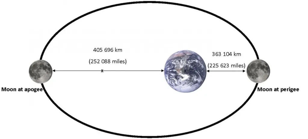
The moon's elliptical orbit showing Apogee and Perigee distances
These orbital variations mean that the moon's appearance can change significantly depending on where it is in its orbit during your chosen date. Our system accounts for these variations to provide the most accurate Moon Map, in our research this is where the largest discrepancy in moon map accuracy was found, many others did ot account for this dynamic variable. which compounds inaccuracies.
7.0 Geographical Coordinates
The Moon's appearance is observer-dependent and is calculated from the user's geographical location. Our systems use the Google Maps API to accurately determine this variable; the user can search via postcode, city, or place name to define the location used for the final Moon Map product.
Moon Phase Prints use topocentric geometry—calculations from the observer's position on Earth, not from the Earth's centre—so that the print matches what was physically visible. Accurate geographic coordinates are essential and, together with the Culmination Moon Map Method™, ensure the Moon is faithfully represented.
Observer Location Matters
The moon's appearance varies slightly depending on your location on Earth. The angle at which you view the moon, and therefore the orientation of its illuminated portion, changes based on your latitude and longitude. Our system calculates these subtle differences to ensure accuracy.
Geographic coordinates based on the Earth's reference ellipsoid provide the precise observer position needed for accurate moon phase calculations. This ensures that your moon print shows exactly what the moon looked like from your specific location.
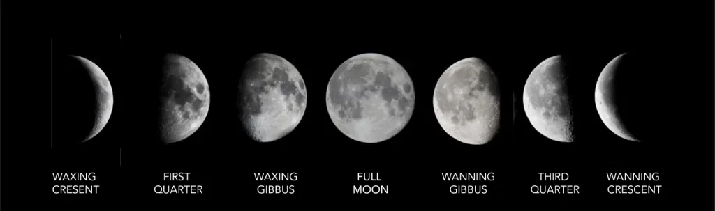
8.0 Lunar Cycle Moon Phase
For the moon phase print, the orbit of the Moon (the lunar cycle) is very important, ensuring the Moon is pictured at the optimum (culmination) phase and time, when it is at its most visible.
The lunar cycle, also known as a lunation, takes approximately 29.53 days to complete. During this time, the moon passes through all of its phases from new moon to full moon and back again.
When you specify a date and location, our system calculates the optimum time when the moon is at its highest point in the sky and most visible from your location. This ensures your moon print captures the moon at its best viewing angle.
The phases of the moon are determined by the relative positions of the sun, Earth, and moon. As the moon orbits Earth, we see different portions of its illuminated half, creating the familiar cycle of phases.
9.0 Lunar Surface Details
Our Moon Phase Prints capture not only the phase of the Moon, but also the physical characteristics of its visible surface. Major lunar features, including the dark basaltic plains (maria) and brighter highland regions, are rendered in their correct positions with appropriate relative brightness.
Surface detail is calculated in conjunction with illumination and viewing geometry, meaning that contrast and shading vary naturally depending on the angle of sunlight and the observer’s position on Earth. This ensures that familiar lunar features appear exactly where they should for the selected moment, rather than being fixed or decorative textures.
While the underlying model prioritises physical accuracy and visibility, the final image is optimised for high-resolution print output. Shading, tonal range, and scale are carefully balanced to preserve surface detail without exaggeration, ensuring the Moon remains faithful to real observation while translating accurately to a printed format.
10.0 Lunar Libration and Orientation
The Moon exhibits a subtle oscillation known as lunar libration, which allows observers on Earth to see slightly different portions of the lunar surface over time. This effect is caused by a combination of the Moon’s orbital eccentricity, axial tilt, and varying orbital speed. Libration affects the apparent orientation of surface features and the alignment of the Moon’s face relative to the observer. Ignoring libration can result in Moon maps that appear rotated or misaligned compared to real observation. Our Moon Phase Prints account for libration to ensure surface features are positioned correctly for the selected date and location.
11.0 Altitude, Atmosphere and Geometry
Viewing the Moon from an observer on Earth involves a combination of variables such as Altitude, Atmosphere, and Viewing Geometry
The Moon’s altitude above the horizon affects how it is observed. When the Moon is low in the sky, its light must pass through a greater thickness of Earth’s atmosphere, increasing refraction, scattering, and contrast loss. Higher altitudes reduce atmospheric path length and generally produce clearer, more stable viewing conditions for that night. For this reason, timing and altitude are considered together when determining the optimal moment to render the Moon.
This is another key reason why using lunar culmination is the most favourable method. And ideal for the best Moon Phase Prints.
12.0 3D Rendering Technology
To achieve the level of accuracy required, we do not simply use 2D calculations. Our moon phase prints are generated using advanced 3D rendering technology that models the moon as a three-dimensional sphere.
This allows us to accurately calculate:
- The exact position and angle of the terminator line
- The libration of the moon (the slight wobble that lets us see different edges)
- The precise shadows cast by lunar features
- The correct orientation based on observer location
This 3D approach ensures that every detail of the moon's appearance is calculated with astronomical precision.
13.0 Moon Size
The Moon at its furthest distance (Apogee) and its shortest distance (Perigee) affects its visual size from Earth. The Moon can appear 12% larger at Perigee than at Apogee.
When the moon is at perigee and full, it is often called a "Supermoon"—a term popularised in recent years to describe this impressive lunar event. The difference in size is noticeable and creates a more dramatic visual effect.
Size Variations
Perigee (Closest)
225,623 miles
Appears 12% larger
Apogee (Farthest)
252,088 miles
Standard size
We display the moon at its largest ratio optimally to the print. However, we can adjust this feature upon request to reflect its actual size based on its position in the lunar cycle on your chosen date.
Ready to Create Your Own Moon Phase Print?
Capture the exact moon phase from your special moment with our astronomically accurate and beautifully crafted moon prints.
Create Your Moon Phase Print