The Science
The Science Behind Location Maps
Our location maps combine cutting-edge cartographic technology with artistic design to create stunning visual representations of any place on Earth. Learn about the precision and technology that goes into every custom location map.
Every location map is a perfect blend of geographical accuracy and aesthetic beauty, capturing the essence of your special place with precision mapping technology.
1.0 Cartographic Precision
Creating an accurate location map requires advanced cartographic data from multiple sources. Our systems utilize OpenStreetMap and Mapbox vector tiles to ensure the highest level of geographical accuracy.
Every road, building, waterway, and landmark is precisely positioned according to real-world coordinates. This attention to detail ensures that your location map is not just beautiful, but geographically accurate.
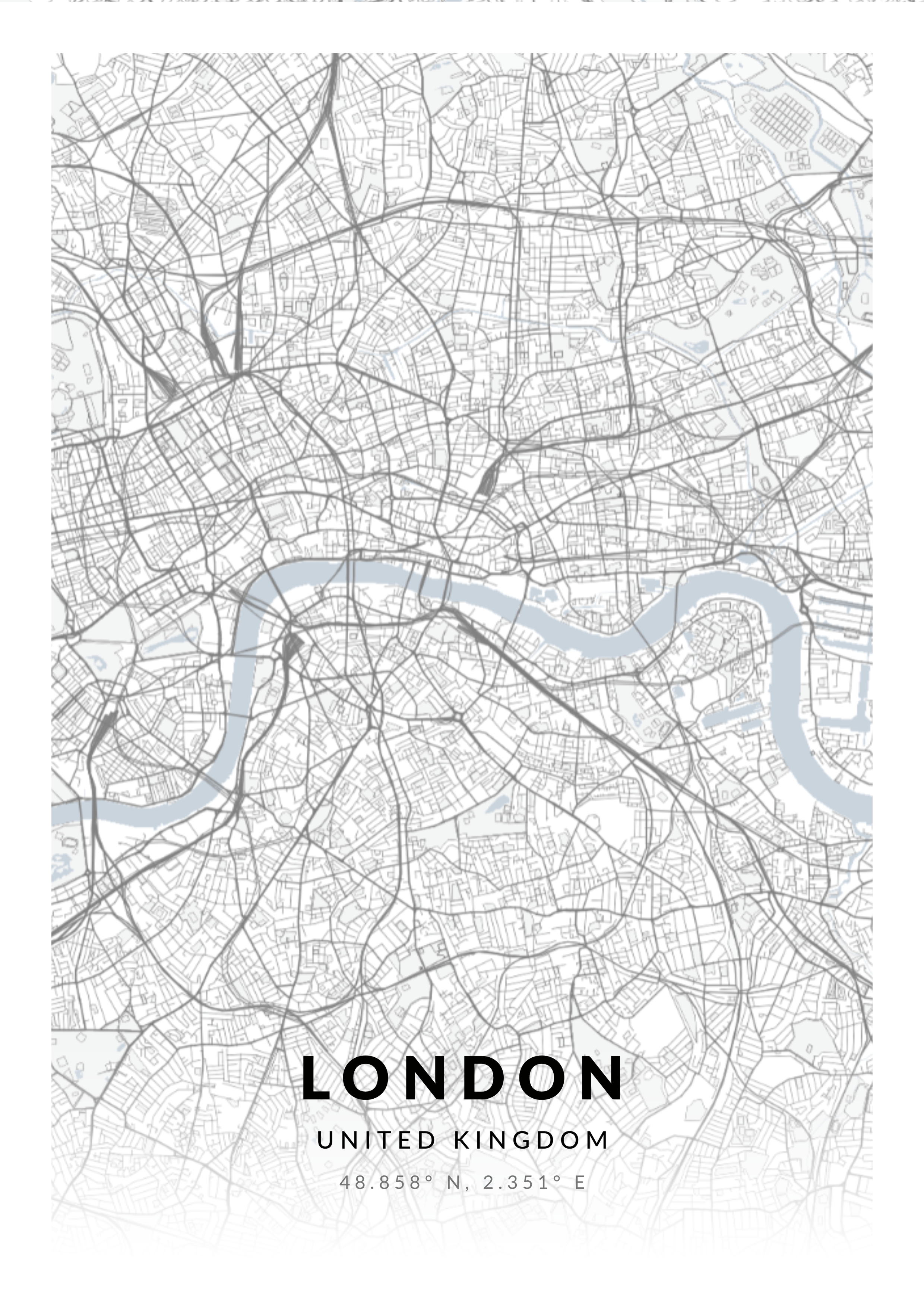
A detailed location map showing the precision of our cartographic rendering
The level of detail displayed is optimized based on the zoom level and size of your print, ensuring the perfect balance between clarity and information density.
1.1 Geographical Coordinates
Just like our star maps, location maps rely on precise geographical coordinates to pinpoint any location on Earth. Our system uses the WGS84 coordinate system (World Geodetic System 1984), the same standard used by GPS satellites.
Latitude & Longitude
Every location on Earth can be defined by its latitude (north-south position) and longitude (east-west position). Our system accepts coordinates in multiple formats: decimal degrees, degrees/minutes/seconds, or simply by searching for an address or place name using Google Maps API.
The precision of our coordinate system allows us to accurately represent your chosen location down to a few meters, ensuring that your map captures exactly the right spot.
1.2 Map Projection Technology
One of the biggest challenges in cartography is representing the three-dimensional surface of the Earth on a two-dimensional map. We use Web Mercator projection for most maps, which provides an excellent balance between accuracy and visual appeal.
This projection system is specifically designed for web mapping applications and maintains true compass bearings, making it easy to orient and understand your location map.
Projection Accuracy
While no flat map can perfectly represent a sphere, the Web Mercator projection minimizes distortion in the areas most commonly mapped. For locations near the equator, the accuracy is nearly perfect. Even at higher latitudes, the distortion is kept to a minimum for the scale of our prints.
1.3 Vector Tile Technology
Unlike traditional raster images, our location maps are generated using vector tile technology. This means that every element on your map—every road, building, and label—is a mathematically defined shape rather than a collection of pixels.
The advantages of vector tiles include:
- Infinite scalability without loss of quality
- Crisp, sharp lines at any print size
- Smaller file sizes and faster rendering
- Complete control over styling and colors
This technology ensures that whether you're printing a small postcard or a large wall poster, your location map maintains perfect clarity and precision.
1.4 Data Sources & Accuracy
Our location maps are powered by multiple authoritative data sources to ensure maximum accuracy and coverage worldwide.
OpenStreetMap
8+ Million
Active Contributors
Mapbox Vector Tiles
Global
Coverage
Google Places API
200+ Million
Places Worldwide
Resolution
300 DPI
Professional Quality
These data sources are continuously updated by thousands of contributors worldwide, ensuring that your location map reflects the most current geographical information available.
The combination of these sources allows us to accurately represent locations anywhere in the world, from major cities to remote villages, capturing the unique character of each place.
1.5 Zoom Level & Detail Optimization
The amount of detail shown on your location map is carefully calibrated based on the zoom level. We use a sophisticated algorithm to determine the optimal zoom level based on your chosen location and print size.
Detail Levels
City Overview (Zoom 10-12)
Shows major roads, districts, and landmarks
Neighborhood View (Zoom 13-15)
Displays streets, buildings, and local features
Street Level (Zoom 16-18)
Shows individual buildings, house numbers, and detailed features
Too much detail can make a map cluttered and difficult to read, while too little detail might not capture the essence of your location. Our system finds the perfect balance automatically.
1.6 Custom Styling & Design
While the underlying geographical data is accurate and precise, the visual styling of your location map is fully customizable. We offer multiple design themes, from classic black and white to colorful modern styles.
Each style is carefully crafted to:
- Maintain readability and clarity
- Highlight important features appropriately
- Create a beautiful aesthetic that complements any decor
- Ensure proper contrast for printing
Our design team has optimized each style to work perfectly with our museum-grade printing process, ensuring vibrant colors and crisp details in your final print.
1.7 High-Resolution Export
Creating a location map suitable for large-format printing requires generating an extremely high-resolution image. Our export process renders your map at 300 DPI (dots per inch), the professional standard for high-quality printing.
For a large poster, this can result in images exceeding 10,000 x 10,000 pixels. Our rendering engine is optimized to handle these large exports efficiently while maintaining perfect quality.
The high resolution ensures that even when viewed up close, your location map remains sharp and detailed, with no pixelation or blurriness. Every street name and feature is crisp and clear.
1.8 Place Name Search
Finding your perfect location is made easy through our integration with Google Places API. Simply search for any address, landmark, business, or point of interest worldwide.
The search system understands:
- Full addresses (e.g., "123 Main Street, London")
- Partial addresses and postcodes
- Landmark names (e.g., "Eiffel Tower")
- Business names and establishments
- Natural features (parks, lakes, mountains)
- Neighborhoods and districts
Once you've found your location, you can fine-tune the exact center point of your map by clicking on the map preview or manually adjusting the coordinates.
1.9 Personalization Options
Beyond the geographical accuracy, our location maps offer extensive personalization options to make your print truly unique:
- •Custom Text: Add your own title, date, or meaningful message
- •Heart Marker: Place a custom marker at your exact location
- •Coordinate Display: Show the precise latitude and longitude
- •Color Schemes: Choose from multiple artistic styles
Ready to Create Your Own Location Map?
Commemorate your special place with our beautifully designed and geographically accurate location maps.
Create Your Location Map