The Science
How our Star Maps Work
Our star maps have an incredible level of accuracy using a selection of online resources and most notably ESA star databases we calculate the stars to a level of accuracy unmatched. The below is a condensed scientific article on our process, evolution and verification of our Star Maps.
Your Star Map is a Unique Bespoke piece of art thanks to the dynamic facts listed below.
1.0 More Space More Stars
Stars are measured on their relative brightness this is given as a variable called magnitude (see 1.6) our systems optimally calculate the level to which stars are calculated and displayed.
We dynamically control the amount of stars based on magnitude so a larger print will show more stars at a higher scale of star magnitude.
It is possible to request multiple versions of your star map at varying levels of star magnitude variance (amount of stars). As standard the optimal level is calculated, of which each size has a different level and scale of star amounts and magnitudes.
1.1 Calculated Precisely
Picture the stars use a combination of star catalogues to obtain Star data points to ensure our continued unmatched high level of accuracy and precision.
Star data includes: Speed, distance, size, brightness (magnitude) and the celestial position (Right Ascension and Declination).
The amount of stars in our combined database is so extensive it would be visually unappealing to display them all, there would be very little blank space (if any).
As such we have optimised the amount of stars to be shown based on Magnitude (star brightness) those stars which are brightest and most visible to the naked eye are always printed. Also we have adjusted this measurement to allow more stars to be displayed on higher print sizes as we have more space on the print to do so.
Hipparcos Catalog
118,000
Stars
Tycho-2 Catalog
2.5 Million
Stars
Gaia Data Release
1.8 Billion
Celestial Objects
Yale Star Catalogue
9,000
Stars
1.2 Geographical Coordinates
Geographical coordinates are a system used to specify locations on the Earth's surface. Our systems use Google Maps API to accurately determine this variable, the user can simple search via their postcode, city or even place name. Geographical coordinates are based on the Earth's reference ellipsoid, a model that approximates the Earth's shape as an oblate spheroid (a sphere flattened at the poles).
The coordinates are illustrated on the star map using the following denominations:
Latitude
is the angular distance north or south of the Earth's equator. It is measured in degrees and ranges from 0° at the equator to 90° at the North and South Poles. The equator itself is defined as 0° latitude. Positive latitudes are used for locations in the Northern Hemisphere, while negative latitudes are used for locations in the Southern Hemisphere.
Longitude
is the angular distance east or west of a reference meridian, typically the Prime Meridian, which passes through Greenwich, London, UK. It is also measured in degrees and ranges from 0° to 180° east or west. The Prime Meridian is defined as 0° longitude, with positive longitudes to the east and negative longitudes to the west.
It is also possible to manually select the coordinates numbers – this will effect the stars position in real time.
It is also possible for the user to change the location text only to something more personal such as "Lydia's Tree House" however the numbers denoting this location will not change. Unless the otherwise specified on a separate data field, all accessible on the product page.
The geographic location on earth is one major vector for the calculation of your star map.
1.3 Celestial Coordinates
Objects in space such as stars use a combination of Right Ascension and Declination to precisely locate their position.
Right Ascension (RA) is similar to longitude on Earth, measuring the angular distance eastward from the vernal equinox, which is the point where the Sun crosses the celestial equator during the spring equinox.
Declination (Dec) on the other hand, is akin to latitude on Earth and measures the angular distance north or south of the celestial equator. It is expressed in degrees, with positive values for objects north of the celestial equator and negative values for objects south of it.
Accurate measurements of celestial coordinates are crucial for the creation of star maps.
Our star maps include an optional grid map which help determine the position of celestial objects.
1.4 Magnitude / Star Brightness
Magnitude (M) is expressed as apparent magnitude in relationship with star maps. Apparent magnitude is the logarithmic scale used to determine a stars brightness as viewed from Earth, factors such as luminosity, distance and atmospherical effects all play a role in the Stars magnitude and brightness.
Sirius is the brightest star in the sky, Sirius is located in the constellation Canis Major.
The lower the number the brighter the star, Stars spanning between 1-6 magnitude are usually visible to the naked eye. Our systems and larger prints span to 13.3 Magnitude, however visible stars are always prioritised and calculated first.
1.5 Astronomical Databases
Astronomical databases differ from star catalogues, where as star catalogues providing valuable star position data, Astronomical databases contain various information and assets such as picture of the galaxy, this is particularly important for the creation of our special star maps such as the Mystic Night Star Map and the Real Photo Star Map which rely heavily on thousands of real photos stitched together.
1.6 Compass
The optional inclusion of a compass/coordinates with our star maps was mainly added as a visual aid however this created an interesting issue, discussed briefly above.
Geographically here on Earth we are used to the following as Poles – North, East, South and West. And most notably in this order only.
However a traditional Star Map is used to navigate the night sky an astronomical plane.
And the way in which traditional star maps display this is counter intuitive at first. This is displayed as North, South, East and West. South and East are effectively switched. This although sounds counter intuitive is in fact the opposite when it comes to using the star map to navigate the night sky.
Understandably however this looks wrong from a customers point of view, and users will be using this primarily as decoration and not to navigate.
This is how we solved this
Rightly or wrongly other website effectively switch these poles before production. So they will swap South and East. Although we understand the appeal of doing this as the star map will look "right" the map is no longer a traditional star map and is effectively back to front.
Our solution was simple we removed the East, South and West labels on the print, and retained the North. This means our star maps are still accurate traditional star maps however will not be perceived as looking wrong with the unfamiliar labelling of the poles.
1.7 Enhanced Milky Way
For the most accurate portrayal of the milky way we recommend choosing the Real Photo star map as this uses thousands of pictures combined to show the whole night sky including the milky way in enhanced quality, for our other star maps we use assets from our Real Photo star map to create a visually superior milky way including illumination, mist and fade.
For the Original Star map we have reduced this effect somewhat to retain its classic and modern simple appeal.
1.8 Exclusive Star Map Designs
Our Exclusive Star map designs are a natural evolution of the Original Star map, made combining new assets with existing technology, Visually the exclusive star map designs are superior and offer a wide range of colour, contrast and atmospheric celestial objects.
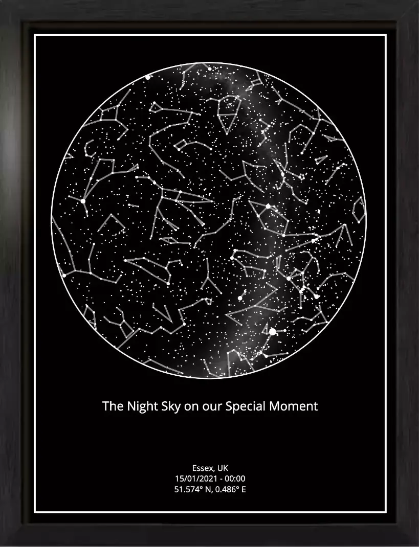
1.9 Constellations
The option to display constellation optional and can be turned on and off, when turned on the lines between the stars are depicted on the printed star map.
There are 88 constellations however not all will show up at once as some are in the northern hemisphere and some are only visible in the southern hemisphere, there is considerable overlap however all based on location and time. You can easily see this by clicking here and testing out your star map with your chosen place and time.
Ready to Create Your Own Star Map?
Capture your special moment in the stars with our scientifically accurate and beautifully crafted star maps.
Create Your Star Map